Why flooding might happen more often in Western Europe
30-07-2021
Central Europe
Bart van den Dikkenberg, RD
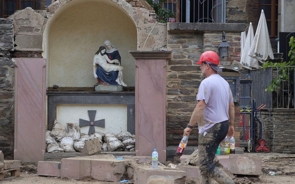
A view of a damaged shrine showing an icon of Mary and Jesus after the flooding of the Ahr River, in Mayschoss in the district of Ahrweiler, Germany. photo EPA, Friedemann Vogel
Central Europe
Once again, the Belgian Ardennes faced heavy rainfalls and massive floods on Saturday. They will occur much more often, scientists expect.
Last Tuesday and Wednesday, more than 150 millimetres of rain fell in some places in the Ardennes. That is more than twice the usual amount of precipitation in July. Locally, a quarter of the total annual rainfall fell in 48 hours. According to scientists, there is indeed something seriously going on.
What caused the floods?
Last week's floods in Belgium, Germany and the Netherlands resulted from a low-pressure area over Germany. This caused extreme rainfall in the Belgian Ardennes, the German Eifel and Southern Limburg.
The thunderstorms moved very slowly over the Eifel and the Ardennes. The slower such storms move, the more rain falls locally, thus creating greater chances of floods.
What do these floods have to do with climate change?
Two mechanisms behind this reinforce each other. The atmosphere is warming due to climate change. Dutch summers have become about 2 degrees warmer since the benchmark year 1850. The warmer the atmosphere, the more water vapour it can contain. The more water vapour in the air, the heavier the thunderstorms can become. As a result, showers have about 14 per cent more water than in 1850.
When severe thunderstorms move slowly, vast amounts of precipitation can fall locally. Both mechanisms significantly increase the risk of floods, especially in hilly areas.
By the year 2100, these slow-moving heavy showers will be 14 times more common in Europe, especially in August. Research done by British scientists from Newcastle University and the Met Office shows this. According to computer models, the showers will become much heavier and move even more slowly, says lead researcher Abdullah Kahraman of Newcastle University. We now know the devastating consequences of this.
What makes those thunderstorms move so slowly?
This could also be linked to climate change. Global warming continues. The Arctic is warming two to four times faster than the worldwide average. At the same time, the warm Gulf Stream is weakening in the Atlantic Ocean. As a result, the temperature difference between higher and lower latitudes becomes smaller. This causes a slower jet stream, a 'river' of fast-moving air high in the atmosphere. This summer, the jet stream is 10 to 15 per cent weaker than it used to be. As a result, it has too little energy and speed to push high and low-pressure areas out of place.

Due to this decelerating jet stream, high-pressure areas with abnormally high temperatures and drought are lasting longer and longer, as was the case in Western Europe last year. Low-pressure areas with extreme amounts of precipitation as in recent weeks, too. Scientists warn that "very extreme extremes" will become more frequent in the coming years. "The consequences are disruptive and are likely to get worse," Chris Rapley, a climate science professor at University College London, told The Guardian.
What do scientists expect regarding rainfall and flooding in the future?
Doing nothing is expensive. Then there will regularly be devastating mud and debris flows through German, Belgian and Dutch towns and villages. The densely populated areas prove vulnerable to flooding. The estimated damage for the past floods is 7.8 billion euros. If we do nothing, by 2100, flood damage could amount to as much as 48 billion euros a year. The number of people affected could more than double to about 350,000, the European Commission's Joint Research Center has calculated. Therefore, in the coming years, the Dutch government wants to allocate 500 million euros annually to combat flooding.
So we have to prepare for more frequent extreme rainfall. How do we do that?
In general, the large Dutch rivers did not cause as many problems as the smaller tributaries did. Governments can take technical measures there, such as strengthening dikes, creating overflow areas, and retaining water for longer. A shining example is the Dutch' 'Room for the River' programme. Because river channels have been widened and deepened and the land has been designed as an overflow area, the flood peaks on the Meuse have been reduced by as much as 1 metre. This says Nathalie Asselman, an expert in flood management and advisor to the Dutch government at the Deltares research institute.
According to Fred Hattermann of the German Potsdam Institute for Climate Impact Research, governments should also consider where they can build more climate-proof new houses. This he said to the Reuters news agency. Governments need to review their flood risk assessments, improve warning systems and prepare populations for disasters. Hatterman: "But if it rains heavily, none of that will help; we will have to learn to live with it."
Christian Kuhlicke of the German Helmholtz Center for Environmental Research: "If you can't stop the water, if you can't save your buildings, at least make sure that all vulnerable people from these places can evacuate in time."
This article was previously published in Dutch daily Reformatorisch Dagblad on July 27th, 2021


Related Articles